


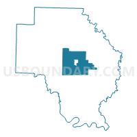
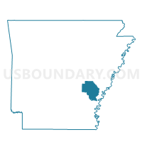
Lagrue Voting District, Arkansas County, Arkansas
About
Outline

Summary
| Unique Area Identifier | 525829 |
| Name | Lagrue Voting District |
| County | Arkansas County |
| State | Arkansas |
| Area (square miles) | 74.31 |
| Land Area (square miles) | 73.38 |
| Water Area (square miles) | 0.92 |
| % of Land Area | 98.76 |
| % of Water Area | 1.24 |
| Latitude of the Internal Point | 34.29074470 |
| Longtitude of the Internal Point | -91.31903380 |
Maps

Graphs
Select a template below for downloading or customizing gragh for Lagrue Voting District, Arkansas County, Arkansas


Neighbors
Neighoring Voting District (by Name) Neighboring Voting District on the Map
- Bayou Meto Voting District, Arkansas County, AR
- Dewitt Ward 1, Arkansas County, AR
- Dewitt Ward 2, Arkansas County, AR
- Dewitt Ward 3, Arkansas County, AR
- Garland Voting District, Arkansas County, AR
- Keaton Voting District, Arkansas County, AR
- Mill Bayou Voting District, Arkansas County, AR
- Point Deluce Voting District, Arkansas County, AR
- Prairie Voting District, Arkansas County, AR
- Stanley Voting District, Arkansas County, AR
Top 10 Neighboring County Subdivision (by Population) Neighboring County Subdivision on the Map
- La Grue township, Arkansas County, AR (4,489)
- Keaton township, Arkansas County, AR (892)
- Stanley township, Arkansas County, AR (720)
- Prairie township, Arkansas County, AR (609)
- Mill Bayou township, Arkansas County, AR (550)
- Point Deluce township, Arkansas County, AR (202)
- Bayou Meto township, Arkansas County, AR (187)
- Garland township, Arkansas County, AR (134)
Top 10 Neighboring Place (by Population) Neighboring Place on the Map
Top 10 Neighboring Unified School District (by Population) Neighboring Unified School District on the Map
Top 10 Neighboring State Legislative District Lower Chamber (by Population) Neighboring State Legislative District Lower Chamber on the Map
Top 10 Neighboring State Legislative District Upper Chamber (by Population) Neighboring State Legislative District Upper Chamber on the Map
Top 10 Neighboring 111th Congressional District (by Population) Neighboring 111th Congressional District on the Map
Top 10 Neighboring Census Tract (by Population) Neighboring Census Tract on the Map
- Census Tract 4807, Arkansas County, AR (2,972)
- Census Tract 4806, Arkansas County, AR (1,747)
- Census Tract 4802, Arkansas County, AR (1,643)
- Census Tract 4801, Arkansas County, AR (1,435)
- Census Tract 4808, Arkansas County, AR (1,424)